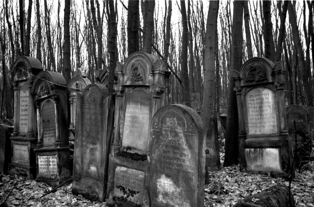
When I was younger, I remember hearing the phrase ‘Poland is one big Jewish cemetery’. This was a way of relating the fact that 90% of Polish Jews were murdered during the Holocaust. Usually it was stated by someone who was explaining why they would never visit Poland. Of course, when I was younger it was quite difficult to visit Poland, being that it was behind the Iron Curtain. I first visited Poland, less than two years after the fall of the Soviet Union, as part of the March of the Living in 1993. We visited a couple of cemeteries during that trip, including the Okopowa St. synagogue in Warsaw. The Okopowa St. cemetery has more than 80,000 gravestones still in existence, and has had money contributed to it from the local government to help preserve it. One wonders if the interest in preserving this particular cemetery is due to an interest in preserving the past, or perhaps an interest in encouraging more Jewish tourism. The lack of funds for other cemeteries in the country would tend to support the tourism theory.
I’ve had a lot to write since visiting the Okopowa St. Jewish Cemetery a few weeks ago, but have too busy to put it all together. After my first visit hours after arriving in Poland that Sunday, I wrote my initial thoughts in Practical suggestions when photographing cemeteries. I visited a second time a few days later on Wednesday and I wanted to share my thoughts on that visit, and what I’ve had time to think about since returning from Poland.
GPS Mapping
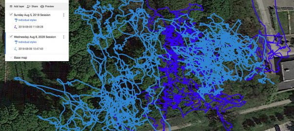
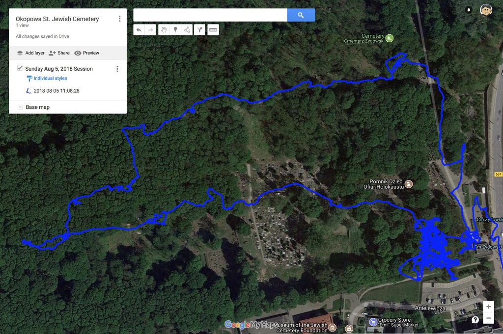
The first thing I wanted to discuss is the idea of using GPS to help map the sections of a cemetery. While the Okopowa St. Cemetery has several maps, once you’re on site, they’re only useful in a general sense. It would be amazing if there could be an app that would show you which section you were in on a moving map. In my earlier post I showed an overlap on a satellite image of where I walked on the first day, which was densely packed in Section 1, and then a walkabout around the cemetery.
On the second visit, I photographed more of Section 1, which you can see in this new map:
Tracks of two visits to Okopowa St. Cemetery
The original path from Sunday is shown in dark blue, and the second path from Wednesday is in light blue. This is a close up showing just the part of Section 1 I visited. There is overlap, and you can see I photographed gravestones to the right of the original area, as well as to the left. All of this is still Section 1 in the cemetery. Continue reading Learning from Okopawa St.→
Yesterday I arrived in Warsaw for the 2018 IAJGS International Conference on Jewish Genealogy. After dropping off my bags at the hotel, I headed straight to the Okopowa St. Cemetery to start photographing the gravestones (as part of the Okopowa St. Project). This was the first time I had visited this cemetery in 25 years (you can see some of the photographs I took then in my article on Jewish Gravestone Symbols).
I wanted to share my experience going to photograph this cemetery, and offer advice that will be useful for other participants in the Okopowa St. Project, but also anyone looking to document cemeteries (and indeed the point of the Okopowa St. Project is to develop best-practices to use for other cemetery documentation projects).
My first advice is simply to dress appropriately for trudging through a cemetery. When I mentioned this to someone yesterday, they asked if I meant for purposes of modesty (tziut in Hebrew). That’s not what I mean. It’s possible, particularly in some cemeteries in Israel, that you may be required to dress modestly when entering a cemetery. My primary concern, however, particularly in an old cemetery like the one in Warsaw, where gravestones are falling over and there is a lot of vegetation growing around, and sometimes on, the graves, is that you need good shoes and long pants, as you will be walking on uneven ground and stepping over branches and other obstructions, possible dealing with mud, etc. Wear a hat and use sunscreen. Some good bug spray with DEET is also recommended.
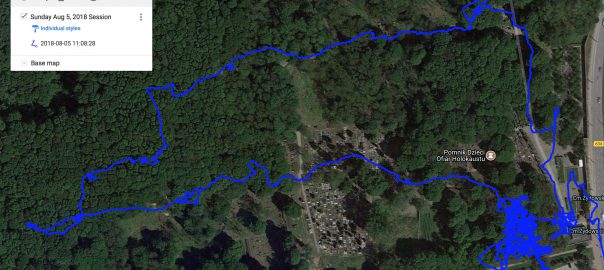
Before going to the cemetery, do some research on what is known about it. Are there maps of the cemetery that will help you navigate the grounds? In the case of the Okopowa St. Cemetery, there are several somewhat-conflicting maps (as shown in my earlier article Okopowa St. Cemetery Maps and Statistics). Bring a map with you if you can. If there is no map, then think about tracking where you go to help create a map. It’s worth showing this image of the cemetery overlaid with the path I walked in the cemetery:
The important thing to notice in this map is the dense area on the bottom right. That shows me walking back and forth along the rows in the first half or so of section 1 in the cemetery. After doing that for some time, I then took a walk around other sections of the cemetery and back to the entrance.
Note that when walking in that section, the lines overlap a lot. That’s because there is no walking in a straight line in that section. Besides trees, some graves are surrounding by fences that block one from walking in some areas, and you end up needing to go back, walk around to the other side, take pictures, then go back around to where you started.
One of the main reasons I elected to use BillionGraves is its ability to link multiple photographs of the same grave. Looking at gravestone photos, I frequently want photos from different angles, or close up photos of the text, etc. Unless the text is very clear and takes up most of the gravestone surface, I like to take at least two photos of each grave – one of the entire gravestone showing the surrounding area, and one close up photo of the text. Here’s a video showing how I do this using the BillionGraves app:
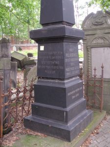
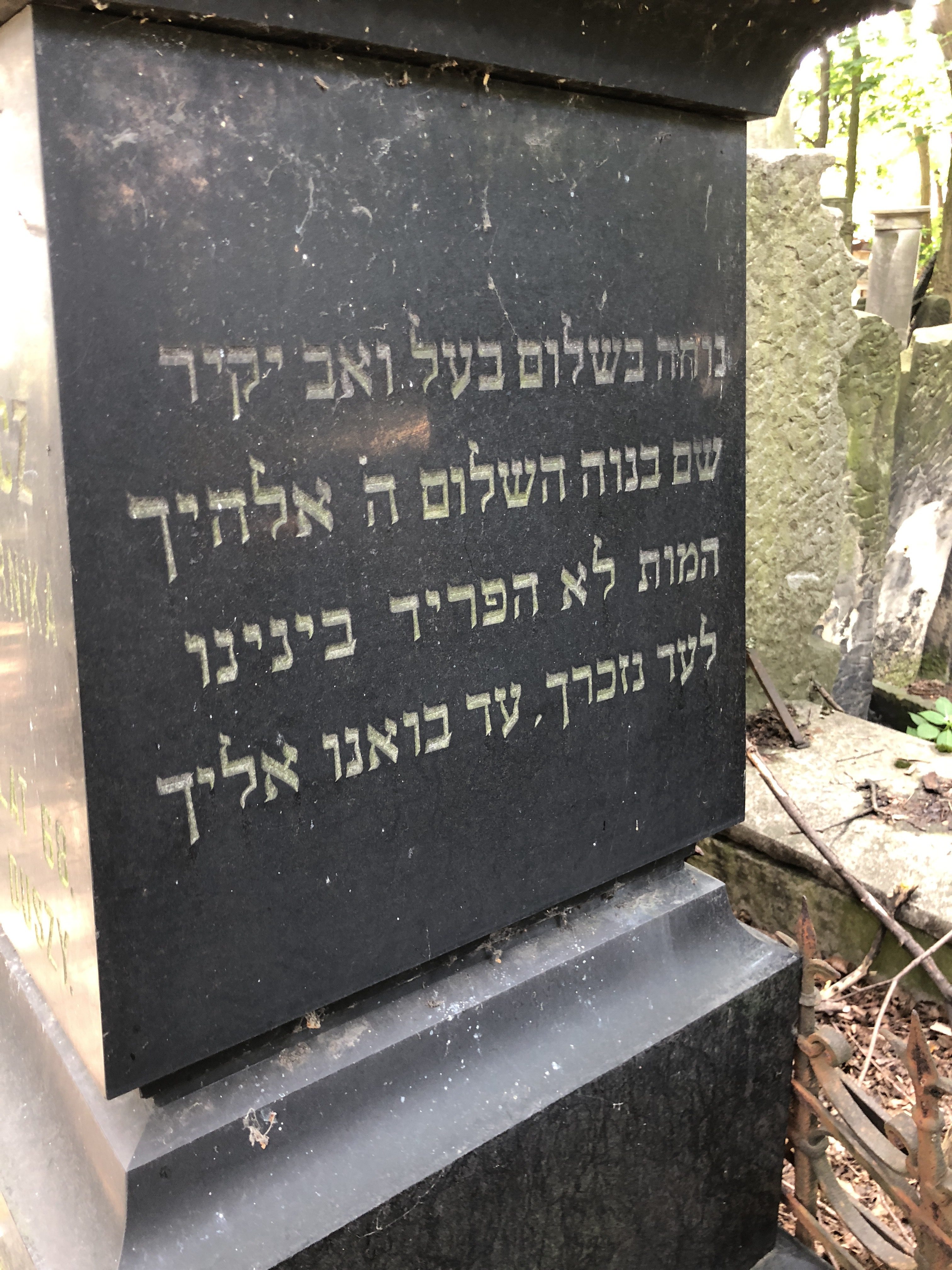
There’s another reason to have multiple photos of a single gravestone, and that’s when the gravestone has text on different surfaces. Let me give an example. It’s not uncommon with Jewish gravestones to have both Hebrew and another language on the stone. Sometimes those texts are on opposite sides of the same stone. In that case you might find a photograph of a gravestone, and not realize there is more text on the opposite side. Here’s an example in the Okopowa St. Cemetery. Below is a photograph of a gravestone on the existing database of burials in the cemetery:
Wolf Polakiewicz gravestone from FDJCP database
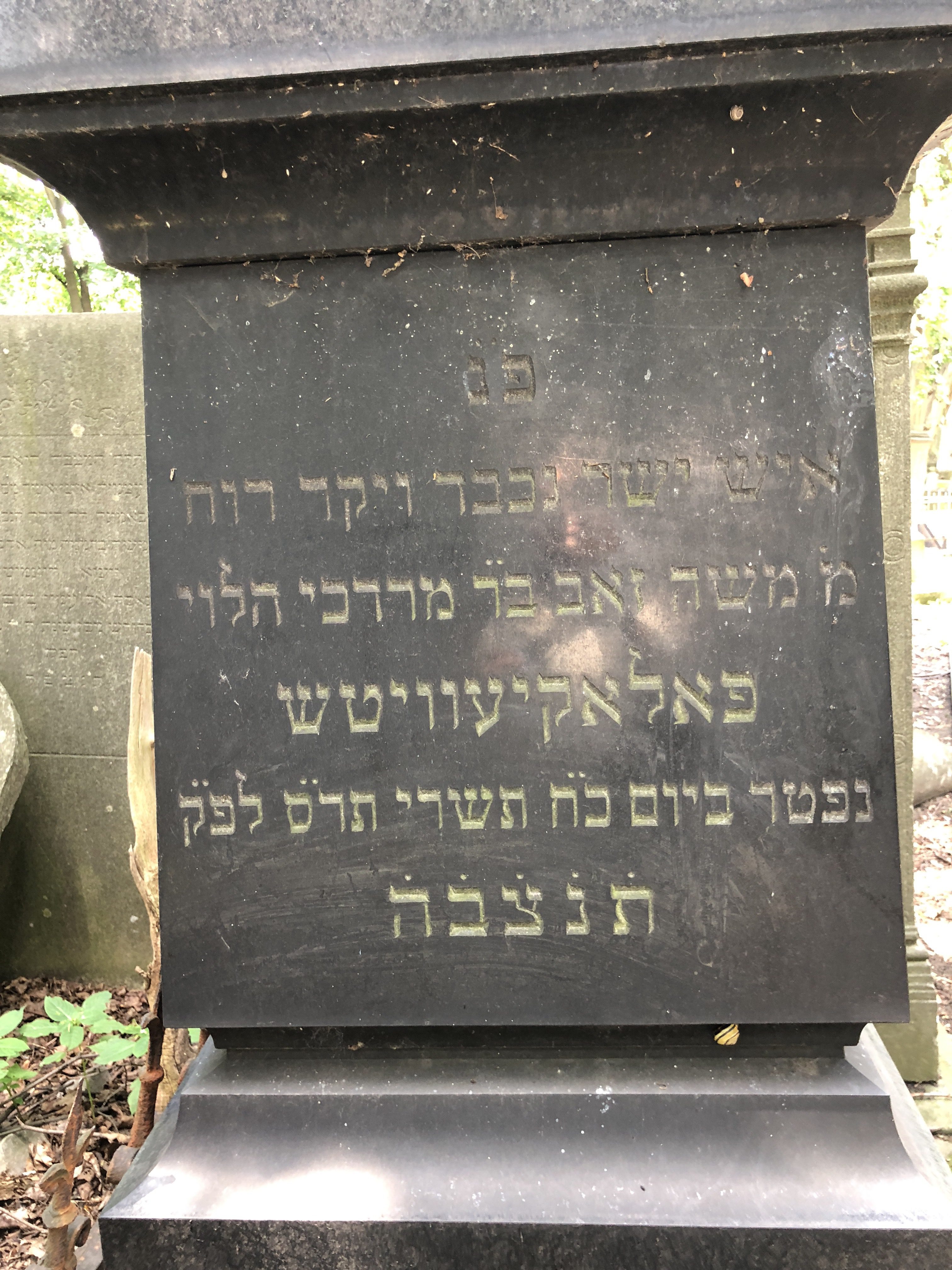
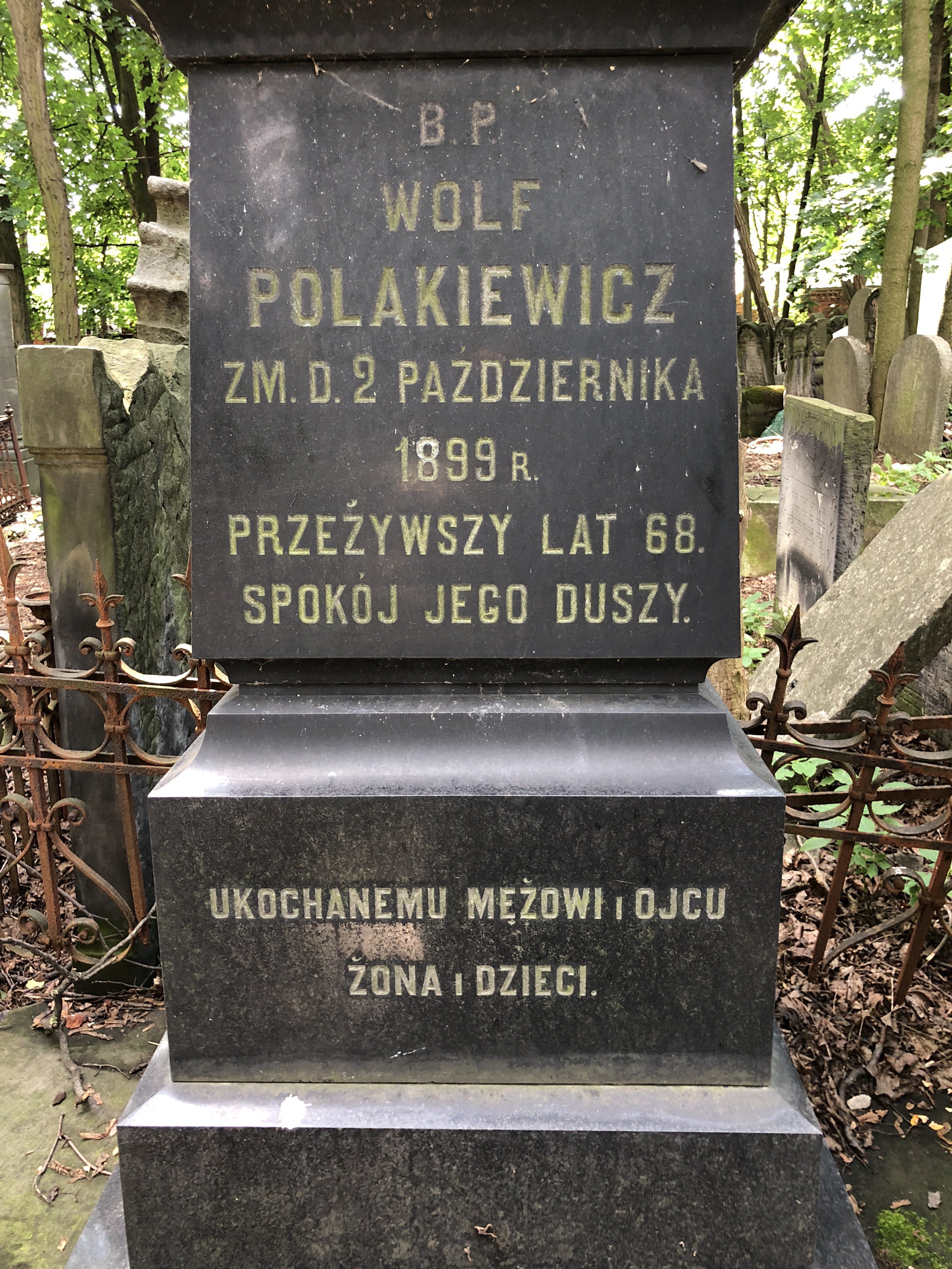
Now let me start with saying that the FDJCP has done an amazing job building their databases. They take the effort to extract the data from gravestones in the field, instead of doing so from photographs, which is many times difficult. They don’t, however, transcribe the entire text on gravestones, which can sometimes be useful, and certainly gives people a more personal look at their relatives than just the extracted names and dates. Note that in the FDJCP photograph, that there are two sides with text. They took a picture at an angle that allows you to see both sides. Now look at four photos I took of the same gravestone yesterday:
On the left you’ll see a photo of the entire stone. Next you’ll see the close-up photos of the two sides shown in the FDJCP photograph. I think anyone would agree that it is easier to read the text in these photos. The last photo on the right is actually a third side that has text. Considering the FDJCP’s goal is not to do transcriptions, but only to extract the important genealogical details, the fact that they don’t show a side of the gravestone with text may not matter to them, but it could matter to a relative looking for every detail possible.
I don’t fault FDJCP, quite the contrary. They’re doing amazing work with limited resources. This is, however, a good example of how we can all contribute to improving what is available.
I hope people find this useful, both for the Okopowa St. Project and for other cemetery documentation projects. If you’re photographing cemeteries this week, whether this one or others, share what you’ve learned in the comments.
As the Okopowa St. Project is about to begin, I wanted a way to help coordinate efforts and share experiences. While each section has a discussion group within Flickr, until now I didn’t have a single group that was easy for people to discuss the project. I’ve now set up a Facebook group for that purpose. If you are participating in the project, or even just thinking about it, please join the group and the discussion.
Also, I’m happy to announce that after discussing things with BillionGraves, we’re going to be able to extract the images from BillionGraves and make them available, even if you don’t separately upload them. This means that even if you only photograph using the BillionGraves app, and don’t manually upload the photos to Flickr, we’ll still be able to get them and make them available.
There’s a catch, however, and that’s the reason we did this, which is that BillionGraves doesn’t embed the geocoding in the images, either the ones they upload or the ones they save to the camera roll. The images are also shrunk when uploaded, so those images won’t be full quality. Therefore we still need you to register on the project on the Google Sheet, so we can figure out which sections each photograph goes to. If you can save the images to your camera roll on iPhone (or use the Android Widget feature which allows you to both upload to BillionGraves and save the photo to your camera), and then upload them to Flickr, we will still end up with better quality images for everyone, and it will make the process much easier on the backend.
We’ve also set up a registration page with BillionGraves, that lets them know you’ve come in through this project. If you haven’t signed up with BillionGraves yet, then please do so through this link. If you’ve already registered on BillionGraves, then just go to the page and sign-in through the ‘Login’ link at the bottom.
Just to be clear, I am very grateful for the assistance BillionGraves is providing us, and their accommodating our needs for this project. We have no financial relationship. I only started speaking to them after the project was announced, when someone assumed I had coordinated this with them and was somehow benefitting from it. I thought to myself that while I have no interest in benefiting from this project, maybe it wasn’t such a bad idea to coordinate with BillionGraves since we were going to be using their software. They really couldn’t have been any nicer, and I am hopeful we can build on this relationship in the future as we use the knowledge gained in photographing this first cemetery, into starting more projects to do the same in other cemeteries.
To make it easier to decide which section of the Okopowa St. Cemetery that volunteers will photograph (as part of the Okopowa St. Project), I’ve been looking at the maps and existing data, to see if I could provide information that would be helpful.
While most cemeteries that existed before WWII in Poland have little in the way of maps to guide you around the cemetery, the Okopowa St. Cemetery has a glut of them. The problem is that these maps are not always consistent. Take for example, the following maps I located online:
Gesia
JRI-Poland
Wikimedia
JHI
These are just four maps, and there are several more available. The three on the left are all fairly similar. They all leave out sections 1A and 1L (sub-sections of section 1), and they have two section 8s, instead of an 8 and 8A.
The map on the right, which is what I initially used to set up the section groups for this project, was designed by the Jewish Historical Institute, and is posted on the web site of the Jewish Community of Warsaw. Unlike the others, this map has a single section called 105, which on on the other maps is divided among 105, 106, and 107. This map has a section 8A replacing one of the two section 8s in the other maps.
None of these maps show section 7, which is actually in the lower portion of section 15, above where section 8A is on the JHI map.
The largest source of information on the burials in the Okopowa St. Cemetery in in the online database created by the Foundation for the Documentation of Jewish Cemeteries in Poland (FDJCP). If you take a look at the database and the information on more than 82,000 burials, you can get overwhelmed. As I mentioned previously (in The challenges of online cemetery research) the FDJCP database has very strict searching, so for example searching for Cohen returns nothing, but Kohen has several hits. The database has a lot of information, but also does not match up with any of these maps.
While all of the maps shows sections 2A, 2B, and 2C, the database is completely missing section 2B. It’s also missing any data on Section 5A (which is in all of the maps), has sections 12A and 12B (not on any map, although there are 2 section 12s, so presumably they’ve divided those into A and B), is missing section 16 (but does have 16A), has a 17A which is not on any map, has sections 64, 64A, and 64B, while the three maps on the left show two sections called 64, the JHI map shows those two sections labeled 64A and 64B, but does not have a third section called 64, and lastly the database is missing sections 101, 102, 103, 104, 106 and 107 altogether.
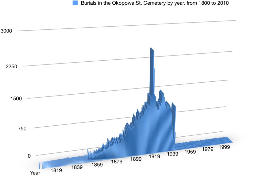
Taking a look at the data, you can extrapolate some interesting statistics. Keeping in mind that the data is not complete (gravestones that are damaged, sunken, or missing cannot contribute their information), sometimes has inaccuracies (such as the wrong gender assigned to a burial record), I’ve put together some information on burials, which will be useful in choosing a section to photograph. To start, when did the burials take place in the cemetery? Here’s a chart showing the number of burials per year, starting in 1800 and going to 2010. The first burial is actually 1804, although older stones are less likely to be in readable condition at this point, so the chart is probably skewed to more recent burials. This chart is what is known according to the FDJCP database:
What you can see in the chart is that the burials are low in number up until about the 1850s, and then they rise dramatically until there’s a huge peak during WWI and the subsequent Spanish Flu outbreak. There’s another small peak about 10 years later (any have a theory as to what that is?), then a large drop in 1938-1940, followed by a big spike in 1941. In 1942 there are still over 500 burials, but after the war the cemetery will never see more than 25 burials a year (while before the war it averaged well over a thousand a year). Continue reading Okopowa St. Cemetery Maps and Statistics→
This website uses cookies to improve your experience. We'll assume you're ok with this, but you can opt-out if you wish.AcceptRead More
Privacy & Cookies Policy
Privacy Overview
This website uses cookies to improve your experience while you navigate through the website. Out of these, the cookies that are categorized as necessary are stored on your browser as they are essential for the working of basic functionalities of the website. We also use third-party cookies that help us analyze and understand how you use this website. These cookies will be stored in your browser only with your consent. You also have the option to opt-out of these cookies. But opting out of some of these cookies may affect your browsing experience.
Necessary cookies are absolutely essential for the website to function properly. This category only includes cookies that ensures basic functionalities and security features of the website. These cookies do not store any personal information.
Any cookies that may not be particularly necessary for the website to function and is used specifically to collect user personal data via analytics, ads, other embedded contents are termed as non-necessary cookies. It is mandatory to procure user consent prior to running these cookies on your website.