I’ve had a lot to write since visiting the Okopowa St. Jewish Cemetery a few weeks ago, but have too busy to put it all together. After my first visit hours after arriving in Poland that Sunday, I wrote my initial thoughts in Practical suggestions when photographing cemeteries. I visited a second time a few days later on Wednesday and I wanted to share my thoughts on that visit, and what I’ve had time to think about since returning from Poland.
GPS Mapping
The first thing I wanted to discuss is the idea of using GPS to help map the sections of a cemetery. While the Okopowa St. Cemetery has several maps, once you’re on site, they’re only useful in a general sense. It would be amazing if there could be an app that would show you which section you were in on a moving map. In my earlier post I showed an overlap on a satellite image of where I walked on the first day, which was densely packed in Section 1, and then a walkabout around the cemetery.
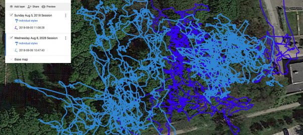
On the second visit, I photographed more of Section 1, which you can see in this new map:

The original path from Sunday is shown in dark blue, and the second path from Wednesday is in light blue. This is a close up showing just the part of Section 1 I visited. There is overlap, and you can see I photographed gravestones to the right of the original area, as well as to the left. All of this is still Section 1 in the cemetery. Continue reading Learning from Okopawa St.