To make it easier to decide which section of the Okopowa St. Cemetery that volunteers will photograph (as part of the Okopowa St. Project), I’ve been looking at the maps and existing data, to see if I could provide information that would be helpful.
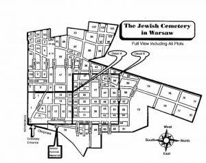
While most cemeteries that existed before WWII in Poland have little in the way of maps to guide you around the cemetery, the Okopowa St. Cemetery has a glut of them. The problem is that these maps are not always consistent. Take for example, the following maps I located online:
 |
 |
 |
 |
| Gesia | JRI-Poland | Wikimedia | JHI |
These are just four maps, and there are several more available. The three on the left are all fairly similar. They all leave out sections 1A and 1L (sub-sections of section 1), and they have two section 8s, instead of an 8 and 8A.
The map on the right, which is what I initially used to set up the section groups for this project, was designed by the Jewish Historical Institute, and is posted on the web site of the Jewish Community of Warsaw. Unlike the others, this map has a single section called 105, which on on the other maps is divided among 105, 106, and 107. This map has a section 8A replacing one of the two section 8s in the other maps.
None of these maps show section 7, which is actually in the lower portion of section 15, above where section 8A is on the JHI map.
The largest source of information on the burials in the Okopowa St. Cemetery in in the online database created by the Foundation for the Documentation of Jewish Cemeteries in Poland (FDJCP). If you take a look at the database and the information on more than 82,000 burials, you can get overwhelmed. As I mentioned previously (in The challenges of online cemetery research) the FDJCP database has very strict searching, so for example searching for Cohen returns nothing, but Kohen has several hits. The database has a lot of information, but also does not match up with any of these maps.
While all of the maps shows sections 2A, 2B, and 2C, the database is completely missing section 2B. It’s also missing any data on Section 5A (which is in all of the maps), has sections 12A and 12B (not on any map, although there are 2 section 12s, so presumably they’ve divided those into A and B), is missing section 16 (but does have 16A), has a 17A which is not on any map, has sections 64, 64A, and 64B, while the three maps on the left show two sections called 64, the JHI map shows those two sections labeled 64A and 64B, but does not have a third section called 64, and lastly the database is missing sections 101, 102, 103, 104, 106 and 107 altogether.
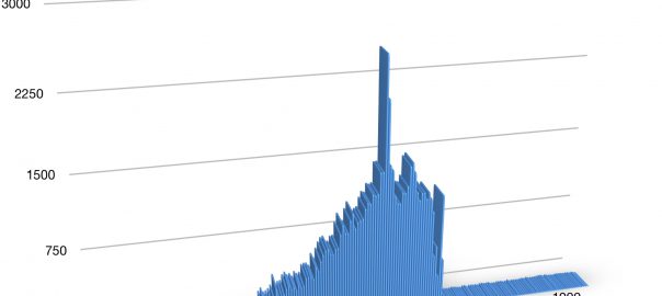
Taking a look at the data, you can extrapolate some interesting statistics. Keeping in mind that the data is not complete (gravestones that are damaged, sunken, or missing cannot contribute their information), sometimes has inaccuracies (such as the wrong gender assigned to a burial record), I’ve put together some information on burials, which will be useful in choosing a section to photograph. To start, when did the burials take place in the cemetery? Here’s a chart showing the number of burials per year, starting in 1800 and going to 2010. The first burial is actually 1804, although older stones are less likely to be in readable condition at this point, so the chart is probably skewed to more recent burials. This chart is what is known according to the FDJCP database:
What you can see in the chart is that the burials are low in number up until about the 1850s, and then they rise dramatically until there’s a huge peak during WWI and the subsequent Spanish Flu outbreak. There’s another small peak about 10 years later (any have a theory as to what that is?), then a large drop in 1938-1940, followed by a big spike in 1941. In 1942 there are still over 500 burials, but after the war the cemetery will never see more than 25 burials a year (while before the war it averaged well over a thousand a year).
Keeping in the differences in the sections mentioned above, I’ve also figured out how many burials there are, and how many rows of gravestones, are in each section. According the the FDJCP database, the sections have the following stats (explanation below):
| Section | Rows | Burials | Gender |
|---|---|---|---|
| m | 21 | 151 | MF |
| zih | 5 | 215 | MF |
| 1 | 53 | 922 | M* |
| 1A | 1 | 28 | M |
| 1L | 7 | 82 | M* |
| 2 | 13 | 105 | F* |
| 2A | 20 | 503 | MF |
| 2C | 10 | 65 | F |
| 3 | 23 | 372 | MF |
| 3A | 26 | 409 | M |
| 4 | 34 | 483 | M |
| 4A | 22 | 367 | F |
| 4B | 29 | 487 | MF |
| 5 | 35 | 1122 | MF |
| 6 | 24 | 705 | MF |
| 7 | 5 | 68 | MF |
| 8 | 23 | 675 | MF |
| 8A | 14 | 255 | MF |
| 9 | 24 | 439 | MF |
| 10 | 12 | 352 | MF |
| 11 | 30 | 554 | F |
| 12A | 31 | 371 | MF |
| 12B | 29 | 863 | MF |
| 13 | 15 | 381 | M* |
| 13A | 16 | 722 | M |
| 14 | 13 | 304 | F* |
| 15 | 36 | 752 | MF |
| 16A | 22 | 194 | F* |
| 17 | 35 | 1919 | M* |
| 17A | 8 | 270 | MF |
| 18 | 35 | 1747 | M |
| 19 | 35 | 452 | MF |
| 20 | 11 | 187 | MF |
| 21 | 12 | 134 | F |
| 22 | 27 | 603 | MF |
| 22A | 35 | 1111 | F |
| 23 | 24 | 679 | F |
| 24 | 19 | 444 | MF |
| 25 | 14 | 248 | M |
| 26 | 10 | 154 | MF |
| 27 | 13 | 158 | F |
| 28 | 29 | 530 | MF |
| 29 | 38 | 1136 | MF |
| 30 | 22 | 894 | F* |
| 31 | 15 | 449 | MF |
| 32 | 21 | 1278 | M |
| 33 | 11 | 495 | MF |
| 34 | 14 | 641 | F* |
| 35 | 17 | 698 | M* |
| 36 | 11 | 458 | MF |
| 37 | 27 | 1765 | M* |
| 38 | 23 | 1141 | F* |
| 39 | 32 | 1293 | F* |
| 40 | 11 | 352 | MF |
| 41 | 32 | 1020 | F* |
| 42 | 26 | 1036 | MF |
| 43 | 20 | 1077 | F* |
| 44 | 3 | 69 | MF |
| 44A | 3 | 78 | MF |
| 44B | 3 | 82 | MF |
| 45 | 35 | 1444 | M* |
| 46 | 11 | 363 | MF |
| 47 | 22 | 1098 | M* |
| 48 | 9 | 329 | M* |
| 49 | 19 | 857 | M* |
| 50 | 19 | 807 | M* |
| 51 | 35 | 1255 | M* |
| 52 | 10 | 220 | MF |
| 53 | 22 | 1007 | F |
| 54 | 17 | 564 | MF |
| 55 | 20 | 882 | F |
| 56 | 35 | 1735 | F* |
| 57 | 13 | 663 | MF |
| 58 | 24 | 1771 | M |
| 59 | 16 | 1543 | F* |
| 60 | 16 | 690 | MF |
| 62 | 13 | 475 | F* |
| 63 | 11 | 376 | F* |
| 64 | 3 | 89 | MF |
| 64A | 3 | 83 | MF |
| 64B | 12 | 306 | MF |
| 65 | 46 | 1768 | M* |
| 66 | 33 | 545 | M* |
| 67 | 18 | 399 | F |
| 68 | 6 | 103 | MF |
| 69 | 1 | 394 | MF |
| 71 | 4 | 571 | MF |
| 73 | 36 | 2883 | M* |
| 73A | 1 | 262 | MF |
| 74 | 23 | 2406 | F* |
| 75 | 25 | 2620 | M |
| 76 | 23 | 2302 | F* |
| 77 | 25 | 945 | M* |
| 78 | 20 | 796 | F* |
| 79 | 18 | 941 | F |
| 80 | 23 | 665 | M* |
| 83 | 29 | 1419 | M* |
| 84 | 32 | 1147 | M |
| 85 | 37 | 1277 | MF |
| 86 | 41 | 1287 | F* |
| 87 | 30 | 1598 | MF |
| 88 | 31 | 1225 | M* |
| 89 | 26 | 820 | F |
| 90 | 7 | 25 | MF |
| 91 | 13 | 421 | F* |
| 92 | 16 | 443 | M |
| 93 | 19 | 162 | MF |
| 94 | 16 | 290 | M* |
| 95 | 31 | 392 | F* |
| 96 | 33 | 548 | MF |
| 97 | 33 | 793 | F |
| 98 | 14 | 363 | MF |
| 99 | 31 | 864 | MF |
| 100 | 24 | 552 | M* |
| 105 | 1 | 98 | MF |
Each section of the cemetery is listed, including two sections not on any map – m and zih. m refers to pieces of gravestones that were incorporated into the wall near the entrance to the cemetery, and zih is the Polish initials of the Jewish Historical Institute (JHI), which apparently managed a section of the cemetery at some point decades ago.
For each section, you can see how many rows there are in the section, and how many burials. You can also see if the section is all or mostly one gender. M or F for Male or Female, and MF for both. When there’s an asterisk after the letter (i.e. F*), it means the section is almost completely that gender, but there may be a few burials of the opposite gender mixed in. Within each section, even if it is labeled MF, it’s not uncommon for large numbers of rows to be of a single gender.
The information has been added to the Google Sheet for volunteer sign-ups, although since the sections don’t exactly match up to the map the section list is based on, not every section has information, and some may be off (such as Section 5 in the database including what on the map and section list is both section 5 and section 5A).
I hope this makes it easier for volunteers to choose a section to photograph, and will help people coordinate which rows they will photograph when splitting up the work.
I found your article very interesting. I visited the cemetary after finding a relative’s matzevah on the internet. Sadly only his matzevah was found and not his wife.
I suggest you contact Przemyslaw Szpilman who is the director of the Jewish Cemetary on Opotow St. in Warsaw. Maybe he has a better and more up-to-date map of the cemetary.
His email is: [email protected]
I have been communicating with him since before launching this project.
Hi Philip,
I’ve just signed up to do a few of the smaller sections while I’m in Warsaw at the conference, but may be able to do more. I’ll see how I go, and check back on what sections are available.
What a great idea this is – I hope you get some more volunteers.
Naomi
Thank you for signing up. I will be at the Share Fair recruiting volunteers, and I am hoping some people will post photos this week, and show people what’s possible.